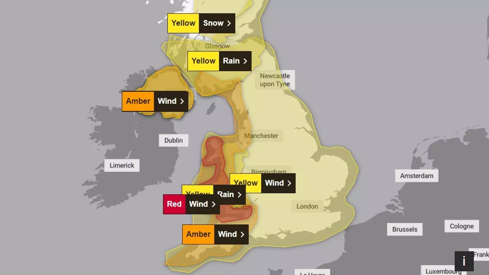
The United Kingdom and Ireland brace themselves for a weekend of severe weather as Storm Darragh approaches, bringing winds that could gust up to 90 mph. The Met Office has issued a red wind weather warning—a rare and serious signal indicating life-threatening conditions. With such warnings in effect, residents are advised to take precautions and remain aware of the potential hazards posed by the storm.
A red weather warning is the highest level issued by meteorological authorities, signaling that extreme weather conditions are imminent. The Met Office emphasizes that these warnings are only deployed when “dangerous weather” is expected to have significant consequences. In this instance, Storm Darragh is predicted to cause severe disruptions across multiple sectors, including travel, energy, and infrastructure.
The gusts of wind associated with the storm threaten to bring down trees and unleash flying debris, making outdoor activities potentially fatal. In affected communities in Wales and the South West of England, including Cardiff, Bristol, and Devon, residents are urged to remain vigilant until the warning is lifted. The warning is in effect from 3 am to 11 am on Saturday, with forecasts suggesting the winds will begin to tone down late in the morning. However, even as winds decrease, strong breezes and additional amber wind warnings might persist throughout the day.
Coastal regions are particularly vulnerable during such explosive weather events. The Met Office warns that large waves coupled with storm surges could inundate vulnerable parts of the coastline, exceeding tidal limits and affecting roads and properties along the shoreline. Residents in exposed coastal areas, especially those in south and west Wales and the Bristol Channel, must remain aware of changing conditions.
In Ireland, Met Éireann has also issued a similar warning as the storm crosses the Irish Sea, impacting regions like Mayo, Galway, Donegal, Leitrim, and Sligo. Gusts of wind bearing the same intensity (90 mph) can result in considerable disruption and danger. Local authorities are mobilizing resources for emergency response, anticipating challenges caused by fallen trees and power lines throughout the storm’s passage.
While wind has taken center stage in these alerts, it is imperative to consider the accompanying rain and potential snowfall. In central Scotland, heavy rain warnings are in effect, expecting accumulations of up to 90mm, which may lead to localized flooding. This forecast is compounded by existing alerts for both rain and snow in various regions across the UK, with parts of Northern Ireland and Wales particularly prone to experiencing adverse conditions.
Rain can exacerbate the effects of strong winds by increasing both the instability of trees and the chances of road flooding—two phenomena that severely threaten motorist safety. The Met Office issues separate amber and yellow weather warnings to prepare communities for additional rainfall amounts, forecasted to arrive when winds are still considerable. Travel services, including buses and trains, could face significant delays; thus, individuals are advised to remain updated on transportation services.
The onus now lies on local governments and communities to respond effectively. With flood warnings already in place, emergency services are equipped to help manage any incidents that may arise throughout the storm’s passage. Residents are encouraged to take proactive measures—securing loose items outdoors and staying indoors during peak storm activity.
As Storm Darragh approaches, it is vital to remind the public to stay connected to news updates and to heed the advice of meteorological authorities. Such awareness and preparation can save lives and reduce the impact of severe weather on those in harm’s way.
Storm Darragh is set to disrupt the lives of many across the UK and Ireland with its potent winds and heavy precipitation. Understanding the risks and preparing accordingly will be crucial as communities navigate through this formidable weather challenge.

Leave a Reply